Find us...
|
|
The farm is located 200m from the small village of Moneystown.
GPS COORDINATES: 53.001356,-6.200881
GPS COORDINATES: 53.001356,-6.200881
From Roundwood...
- Enter Roundwood from north travelling south.
- At the end of the village take the left turn sign posted Rathdrum (R764).
- After 1KM the road curves sharply to the left, You take the turn off straight at the apex of the bend (on to L1076).
- Go Straight through the staggered crossroad with R763, following the signs for Rathdrum.
- After 1.8KM veer left at a fork over a bridge.
- After 100m veer left.
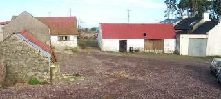
- Arrive in Moneystown with the school and church on the left. Take the right fork and the farm is 100m on the Right (See picture above).
From Ashford...
- Having come off the N11 turn off the R772 at the garda station roundabout onto the R764.
- Travel along the R764, After 350m the road veers right, Take the left turn on this corner sign posted Glendalough.
- Follow the signs for Glendolough and Annamoe.
- Cross tight little Vartry Bridge.
- On a steep up hill with a large ruined wall / building in front of you, take the left turn sign posted Rathdrum (L5092).
- Continue 800m to a crossroads, take the right sign posted Moneystown.
- Continue up and over big hill.
- Aproach Moneystown with the comunity center and pitches on the left and the school and church on the right.
- Turn U-turn to the left
- The farm is 100m on the right. (See picture above)